Every day, satellites capture vast amounts of Earth observation data, offering a near real-time view of our planet. While this data is incredibly valuable, its complexity, multimodality, and rapid refresh rates pose significant challenges in integrating disparate datasets effectively. AlphaEarth Foundations emerges as a groundbreaking solution—an AI model that functions like a virtual satellite, integrating petabytes of Earth observation data into a unified digital representation or “embedding.” This innovation allows for a more complete and consistent understanding of our planet’s evolution, empowering scientists to make informed decisions on critical issues such as food security, deforestation, urban expansion, and water resources.

To accelerate research and unlock practical applications, AlphaEarth Foundations’ annual embeddings are now available as the Satellite Embedding dataset in Google Earth Engine. Over the past year, more than 50 organizations have tested this dataset in real-world scenarios, reporting significant benefits. Partners are using it to classify unmapped ecosystems, understand agricultural and environmental changes, and enhance the accuracy and speed of mapping efforts.
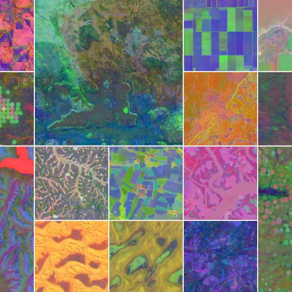
AlphaEarth Foundations addresses two major challenges: data overload and inconsistent information. First, it combines diverse data sources—including optical satellite images, radar, 3D laser mapping, and climate simulations—into sharp 10×10 meter squares, enabling precise tracking of changes over time. Second, it creates highly compact summaries for each square, requiring 16 times less storage space than other AI systems and drastically reducing the cost of planetary-scale analysis. This breakthrough allows scientists to generate detailed, consistent maps on-demand, whether monitoring crop health, tracking deforestation, or observing urban development.

Rigorous testing confirms AlphaEarth Foundations’ superior performance. Compared to traditional methods and other AI mapping systems, it consistently achieves higher accuracy across various tasks, including land use identification and surface property estimation. Notably, it excels even when label data is scarce, boasting a 24% lower error rate on average and demonstrating exceptional learning efficiency.

The Satellite Embedding dataset, powered by AlphaEarth Foundations, is one of the largest of its kind, with over 1.4 trillion embedding footprints per year. Organizations worldwide, including the United Nations’ Food and Agriculture Organization, Harvard Forest, and Stanford University, are leveraging this dataset to create custom maps that drive real-world insights. For instance, the Global Ecosystems Atlas initiative uses it to classify unmapped ecosystems into categories like coastal shrublands and hyper-arid deserts, aiding countries in prioritizing conservation areas and combating biodiversity loss.
In Brazil, MapBiomas is testing the dataset to gain deeper insights into agricultural and environmental changes, particularly in critical ecosystems like the Amazon rainforest. As Tasso Azevedo, founder of MapBiomas, notes, “The Satellite Embedding dataset can transform the way our team works—we now have new options to make maps that are more accurate, precise, and fast to produce.”
AlphaEarth Foundations represents a significant advancement in understanding our changing planet. Future integrations with general reasoning LLM agents like Gemini could further enhance its capabilities. As part of Google Earth AI, this model continues to explore innovative applications to address the planet’s most critical needs, empowering researchers and organizations with cutting-edge geospatial intelligence.